Andy and I are not spontaneous people, and I’m unapologetic about that. We’re not boring, but to those who live a bit more spur-of-the-moment perhaps we come across as inflexible. We’re planful people who like to know what we’re doing when, and as far in advance as possible. When it comes to travel, we don’t plan out every minor detail, but generally we’ll always have a rough idea of the shape the day will take with the things we don’t want to miss out on booked well in advance.
Every so often though, we live a day that becomes so much better than originally planned, because we pivot. This was one of these days, and so though we didn’t overnight at Mount Robson, it deserves its own post because it turned into such a truly awesome day.
A Lazy Start
It’s a 320km (or 4 hour) drive to Jasper. We don’t wake particularly early and we’re not yet slick at what I’m calling ‘van admin’, doing all the bits and bobs to pack up the camper and leave a site. We plan to stop in Clearwater for brekkie before hitting the road, and we’re conscious of the time zone change ahead, losing one hour as we cross the provincial border between British Columbia and Alberta. Additionally, we need groceries, fuel, and a lunch stop somewhere. A half hour leg stretch on that journey is probably all we have time for if we don’t want to be overtired and cranky by dinner time. In short, a rather prosaic day, in the grand scheme of the Rockies Roadie, awaits.
But we take everything at a rather leisurely pace this morning. It’s day seven of the big trip, and what Andy calls ‘the unclenching’ ( when you finally start to relax on a holiday) has begun. In Clearwater town, we’re unperturbed by the out-the-door queue at Wild Flour bakery. The elimination of the option to have a filling and balanced sit-down meal (due to the overall busyness of the place) doesn’t bother us either. We opt for some baked goods: a pumpkin scone, a cheese scone, a cinnamon scroll, and a banana and cranberry cookie. We sit outside the café in the early morning sun, appraising our bready breakfast, and catching snatches of conversation between the friendly local mechanic and some tourists with car trouble, at the garage next door. It’s 10.30am by the time we hit the road.
On Canadian Roads & Rest Stops
Allow me a brief segue here, friends, to talk about some of the more mundane features of a Canadian Roadie.
The roads are, in general, excellent. Even leaving Vancouver, and with all the roadworks underway (my theory is that September is the season where Canada fixes everything up for Winter, post the impact of the Summer hordes) traffic ain’t even a thing. However, roundabouts ain’t a thing either. There’s one at the Clearwater junction which seems to operate quite well, but Canadians are big fans of crossroads and 4-way stop signs at intersections (we’re still not super-clear on the rules of ‘who gets to go’ when we meet one of these, but everyone seems to ‘go’ in the order they arrive at the junction in – it works).
I’m a fan of the ‘variable speed corridor’: there’s no default speed limit indicated; instead, the speed limit is altered based on the conditions that day, appearing on digital signage only.
What Canada doesn’t do so well is public toilets. As you’re no doubt aware, there are some big distances between certain towns and cities. Signage often advises you to fuel up your vehicle, but you should absolutely take advantage of café and restaurant washroom facilities when you ‘fuel up’ yourself as public toilets range from hard-to-find, to non-existent, to ‘pit toilets’ at highway ‘rest areas’. A pit toilet is a long drop, and just like being in the NZ backcountry, it’s an absolute lottery as to how stanky or clean these are. I got one on a day where it had just been cleaned as I was hit with the smell of bleach and woodchip when I entered. But most of the time, I haven’t been so lucky.
So, if you’re driving long distances, do yourself a favour: be ‘a paying customer’ – buy something, anything (though probably not the weak-ass coffee) – and use the rest room before you hit the road.
Mount Robson: An Awesome Sight
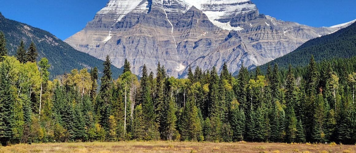
We’re on the lookout for Mount Robson, the highest peak in the Canadian Rockies, standing at an elevation of 3,954m. Living in New Zealand these past 13 years, we’ve become a bit used to spectacular scenery (though we do make an effort to stay mindful in the presence of it) but I can quite honestly say I experience a moment of true awe as we round a corner of the Yellowhead Highway and Mount Robson appears right in front of us.
It is truly striking. The highway is roughly 850m above sea level so over 3,000m of unbroken, vertical mountain fills the windshield; an uninterrupted wall of rock and ice, the massive South Face rises steeply, its heavily glaciated summit looming directly above the green forested valley.
We stop for lunch at the café next to the visitor centre, taking the time to examine old monochrome pictures of climbers and skiers, and read about the history of the mountain.
A Brief History
Mount Robson was given its English name around 1865 to honour Colin Robertson, an influential fur trader with the Hudson Bay Company, instrumental in directing trade routes through the Yellowhead Pass in the early 19th century. Long before European fur traders arrived, the indigenous Shuswap people called the mountain Yuh-hai-has-kun, which translates as ‘The Mountain of the Spiral Road’, referencing its distinct layered horizontal rock strata.
Due to frequent rockfall, severe weather, and steep ice faces, the mountain earned a reputation as an almost unclimbable peak with several unsuccessful attempts to summit in the early 20th century. The official first ascent occurred on 13 August 1913 by Austrian-born mountain guide Conrad Kain, alongside Canadian Alpine Club members Albert MacCarthy and William Foster who reached the summit via the northeast face. Kain spent hours cutting over 600 steps into the steep, hard ice to bring the team up what is now known as the Kain Face.
The first ski descent, in comparison, was fairly recent. Mount Robson is considered one of extreme ski mountaineering’s ultimate challenges due to exposed cliff bands, wild ice formations, and objective danger. The giant North Face was skied for the first time in 1995 (by Ptor Spricenieks and Troy Jungen) but the South Face remained un-skied until just last year (2025). Canadian ski mountaineer Christina Lustenberger and French skier Guillaume Pierrel completed the historic first ski descent via ‘The Great Couloir’, requiring a multi-day effort, steep technical skiing, and seven rappels over exposed cliff bands. (Andy and I watched a 40 minute documentary of this back in June this year; it was a 10-year passion project for those guys to achieve this incredible feat).
The Unplanned Hike
We visit the viewing platform to take some pictures. It’s a bluebird day and the wedge-shaped mountain contrasts sharply against the sky. It’s too short a time to spend in the presence of such an awesome peak but the shortest hike from the trailhead that gets you to anywhere of note (to Kinney Lake) is a 10km return with around 300m of ascent. We agree we’ll just go for that half hour leg stretch as planned. We’ve got the hiking boots on, but we’re not dressed for it otherwise in our cotton shorts and t-shirts.
But we storm uphill over 2km in half an hour, and we keep on going because the terrain is easy, the energy is high, and the powerful Robson River rushes and gushes alongside us all the way. Fed directly by meltwater from the Berg and Mist glaciers, the Robson is milky turquoise in colour due to the glacial flour (suspended rock dust) it carries. It’s a fast-moving torrent filled with white-washing rapids, boulder-strewn drops, and steep chutes. It is spectacularly framed against the dense green cedar, hemlock, and fir forests, over which Mt Robson presides.
Kinney Lake, when we get there, has the same pale turquoise hue. Other than the ripples and splashes from a few shivering swimmers, the lake is perfectly still, reflecting the surrounding mountain peaks and green forests in crisp detail. As well as Mount Robson, the glaciated peak of Whitehorn Mountain and Cinnamon Peak make up the wide alpine panorama across the lake. We spend some time here, taking in the wonder of it all under the full sun of the afternoon.
But we know we have to get back on the road. We make our way downhill, filtering in behind a group of fully-loaded multi-day hikers who have come from further up the Berg Lake Trail (the route to Kinney Lake is but a sub-section of this). There are campgrounds roughly every 5k to Berg Lake (22km from the trailhead), where icebergs calve directly into the turquoise water from Berg Glacier. The newly constructed Robson Pass Hut (operated by the Alpine Club of Canada) accommodates but 12 people, and beds book out very far in advance when reservation windows open for the summer season. Maybe this is the reason for so many mountain bikers on the track as well; 22km is a long way on foot but there and back again on a bike isn’t so bad.
The sheer joy of the group we’re following is palpable. As bikers bounce their fatties down the hill, we vow we’ll come back.
Next Stop, Jasper